
CYCLING and MTB ROUTES
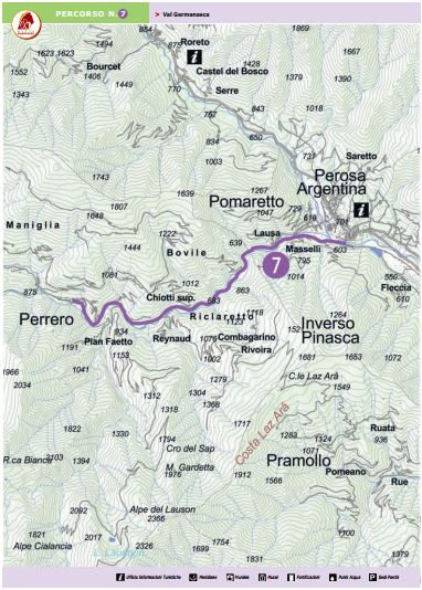 Val Germanasca
Departure – Arrival: Ponte Setificio – Perrero
Lenght: 8,60 km
Total Climb: 220 m
Bike: ROAD
Route: Asphalt
Difficulty: TC
Time Trip: 1 h
Description: From the ex-silk works of Pomaretto with its abandoned buildings and hydroelectric plant, we reach the gorge of the Germanasca Valleywhere the road has worn its way among the rocks towering over the river. The itinerary follows into the valley of the regional Ecomuseum “of the Mines and of the Germanasca Valley” as far as Perrero, where you can visit the Fassi cereal mill.
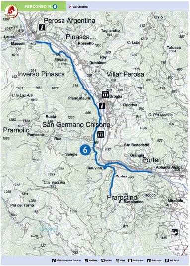 Val Chisone
Departure – Arrival: San Bartolomeo – Ponte Setificio
Lenght: 14,6 km
Total Climb: 140 m
Bike: MTB
Route: Asphalt + dirt track + trail
Difficulty: MC/BC
Time Trip: 1,5 h
Description: This itinerary explores the thrust fault of the lower Chisone Valley: from Porte the itinerary takes you to San Germano Chisone where you can visit the WaldensianMuseum and the Ski Museum, as well as the luxurious urbanpark of Villa Widemann, which today houses the town hall, the starting point of the naturalistic “Verdeacqua” itinerary. Along the route, which ends in Pomaretto, there are also the air-raid shelters of Inverso Pinasca.
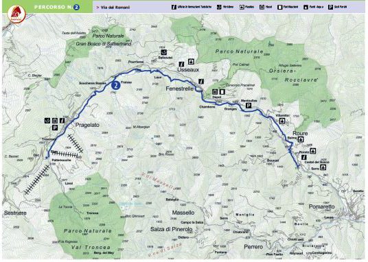 Via dei Romani
Departure – Arrival: Castel del Bosco – Pragelato
Lenght: 36,00 km
Climbing: 815 m
Bike: MTB
Route: Asphalt + dirt track + trail
Difficulty: BC
Time Trip: 5 h
Description: A low-altitude itinerary along the Upper ChisoneValley. This route follows the murals of the town of Roure, the impressive fortress of Fenestrelle, and the uncontaminated nature of Lago del Laux – or Laux Lake – in the town ofUsseaux, one of the “Most Beautiful Villages in Italy”.
Continuing on towards Pragelato, we find the Costume Museum, the Val Troncea Park Museum, and the sundial museum known as “l’Ombra del Tempo” , or “The Shadow of Time”. From here it is possible to continue on to Sestriere.
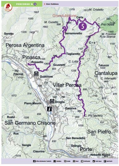 Gran Dubbione
Departure – Arrival: Prà Martino – Pinasca
Lenght: 24,60 km
Climbing: 240 m
Bike: MTB
Route: Asphalt + dirt track + trail
Difficulty: BC
Time Trip: 3,5 h
Description: A highly suggestive itinerary, well off the beaten track, where you can pedal amidst lush and uncontaminated nature.
In the silence of these woods, in the Vallone delle Carbunere, or “Valley of the Coal Miners”, the touristic didactic “Carbonai a Gran Dubbione” itinerary outlines what was once defined as the devil’s trade. Travelling through this magical valley, we find one of the most panoramic and spectacular points of the entire itinerary in Serremarchetto.
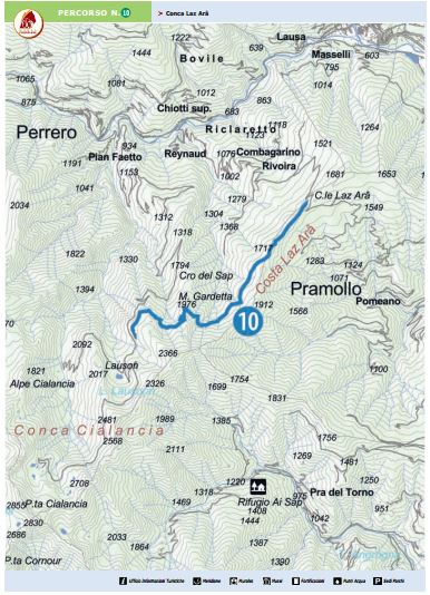 Costa Laz Arâ
Departure – Arrival: Bivio Lauson – Colle Laz Arâ
Lenght: 6,6 km
Climbing: 450 m
Bike: MTB
Route: trail
Difficulty: BC
Time Trip: 1 h
Description: From the Lauson Alps, continue along the Costa Laz Arâ, along the large watershed crest between the Pramollo and Germanasca Valleys, to the Colle del Laz Arâ. The hillside takes its name from the 18th-century French entrenchments, the remains of which are still visible in the terrain.
The route that connects the “Conca Cialancia” and “Pramollo” itineraries remains at a high altitude in a panoramic area where nature still reigns supreme
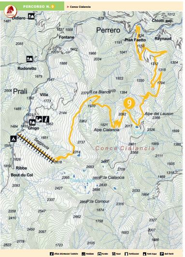 Conca Cialancia
Departure – Arrival: Seggiovia 13 Laghi – Ponte Cialancia
Lenght: 27,70 km
Climbing: 1315 m (salita)
Bike: MTB
Route: Asphalt + dirt track + trail
Difficulty: OCE
Time Trip: 3,5 h
Description: The Malzat – Pian dell’Alpet chairlift takes you to the splendid zone of the Tredici Laghi – or Thirteen Lakes. The itinerary continues at this high altitude in the zone of Rocca Bianca – or White Rock – famous for its marble quarries, and continues beyond the Cialancia Alps and the lake of the Lauson Alps. Along the way you will find the turning of the “Costa Laz Arâ” to continue as far as the deepvalley of Faetto and the Cialancia bridge, just below the town of Perrero.